I-80 Ohio
I-80 Exit 223: Austintown, Ohio
Take it for SR 46 and Niles. I-80 exit 223 lies 1.7 miles outside Austintown (Ohio). Close to the ramps there are 6 gas stations, 15 places to eat and 9 hotels. Counting from the west end of I-80 in Ohio, it is the 29th numbered interchange, 223 miles from the Indiana line.
About 29,600 people live in Austintown. Eastbound, Paterson is 380 miles from I-80 exit 223 (about 6.0 hours). Elyria lies 78 miles westbound, around 72 minutes of driving from I-80 exit 223.
- 6 gas
- 15 food
- 9 hotels
- 0 EV
- Next gas: Eastbound 3 miles · Westbound 14 miles
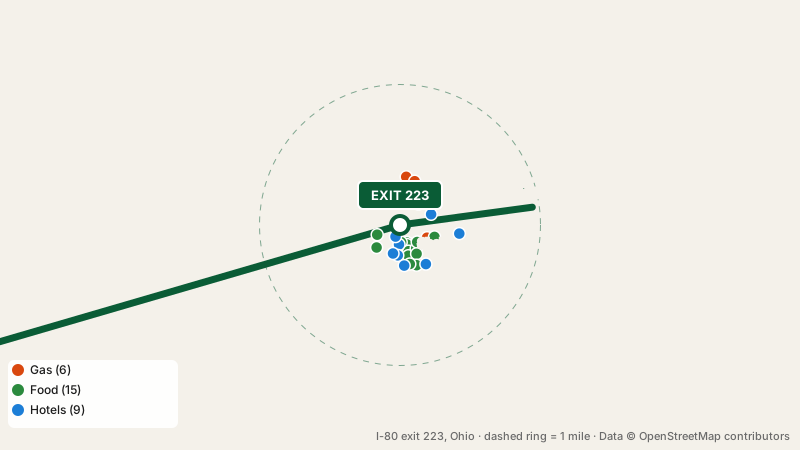
I-80 exit 223 gas and diesel
Nearest to the off-ramp: Shell (0.1 miles). 6 stations compete here: Shell, Travel Centers of America, Sheetz, Pilot and 2 more. Travel Centers of America and Pilot are truck stops serving professional drivers. Eastbound the next gas is at exit 226, 3 miles away; westbound the next gas is at exit 209, 14 miles away.
Restaurants and fast food near I-80 exit 223
Subway leads a mix of 6 fast food spots, 2 cafes and 7 restaurants; others include High Octane Coffee Co, Nick Da Dahba Indian Restaurant and Bar, Taco Bell and 11 more. Cuisines: sandwich, coffee shop, indian and tex-mex.
Spending the night at I-80 exit 223
Need a bed? Quality Inn is 0.1 miles from the ramp, and 8 more places to stay are nearby.
Electric vehicle chargers
There is nowhere to charge an EV at I-80 exit 223. Quick top-ups are possible at exit 226, 3 miles eastbound; otherwise exit 161, 62 miles westbound.
Nearest rest stops
I-80 exit 223 itself has no restrooms beyond its businesses. Next rest area eastbound: Mercer Welcome Center, 18 miles ahead (restrooms). Westbound drivers reach Brady's Leap Service Plaza, 31 miles ahead (restrooms, truck parking).
Two exits each way
| Exit | From here | Services |
|---|---|---|
| Exit 218 Austintown |
5 miles west | |
| Exit 219 Austintown |
4 miles west | |
| Exit 223 Austintown |
– | |
| Exit 224A/B Austintown |
1 mile east | |
| Exit 226 Girard |
3 miles east |
What drivers ask about I-80 exit 223
Is fuel available at I-80 exit 223?
Yes: Shell, Travel Centers of America, Sheetz and 3 more are within a mile of I-80 exit 223.
How far is I-80 exit 223 from town?
Austintown, Ohio is 1.7 miles from I-80 exit 223.
Is there a motel at I-80 exit 223?
Yes, 9 hotels near I-80 exit 223: Quality Inn, Hampton Inn, Holiday Inn Express and 6 more.
Which rest stop is closest to I-80 exit 223?
Mercer Welcome Center, 18 miles eastbound of this exit.
Plan a trip from this exit All I-80 exits in Ohio
Source: OpenStreetMap, · Report a problem