I-80 Indiana
I-80 Exit 10: Gary, Indiana
You will find I-80 exit 10 2.4 miles from Gary, Indiana. Around the interchange you can count on 5 gas stations, 5 places to eat and 1 hotel. Signs at the ramp point to SR 53 and Broadway. At mile 10, this is interchange 7 of 26 along I-80 in Indiana.
Gary (population 67,600) is the local stop for supplies. Eastbound, La Porte is 39 miles from I-80 exit 10 (about 36 minutes). Westbound, Joliet is 40 miles from this exit (about 37 minutes).
- 5 gas
- 5 food
- 1 hotels
- 0 EV
- Next gas: Eastbound 5 miles · Westbound 1 mile
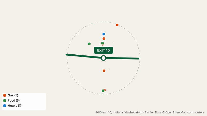
Fuel near I-80 exit 10
Leaving the interchange, Amoco comes first after 0.4 miles. In total there are 5 stations: Amoco, Citgo, Arco, 76 and 1 more. The following fuel stop eastbound is exit 15, 5 miles away; going westbound you can fill up again at exit 9, 1 mile away.
Meals close to I-80 exit 10
Food options near I-80 exit 10: 4 restaurants and 1 fast food spot. The closest is Philly Steak (0.3 miles). Cuisines: steak house, american and ice cream.
Where to stay near exit 10
Budget Motel is the one hotel closest to I-80 exit 10.
Plugging in at this exit
No EV chargers are mapped within a mile of I-80 exit 10. The nearest fast chargers along I-80 are at exit 21, 11 miles eastbound, or exit 1, 9 miles westbound.
Nearest rest stops
I-80 exit 10 is not a rest stop itself. Going eastbound, the next stop is George Ade Travel Plaza, 9 miles ahead (restrooms, truck parking). The westbound lanes lead to Three Rivers Rest Area (Westbound), 53 miles ahead (restrooms, drinking water, vending machines).
What the next exits offer
Quick answers about the interchange
Is fuel available at I-80 exit 10?
It does. Amoco, Citgo, Arco and 2 more are close to the off-ramp.
What town is exit 10 near?
Gary, Indiana is 2.4 miles from I-80 exit 10.
Where can I stay near I-80 exit 10?
Yes, 1 hotel near this exit: Budget Motel.
Is there a rest area near I-80 exit 10?
George Ade Travel Plaza, 9 miles eastbound of the interchange.
Plan a trip from this exit All I-80 exits in Indiana
Source: OpenStreetMap, · Report a problem